What’s vulnerable?
The Fraser River Delta
The Fraser River Delta hosts critical habitats for marine life and migratory birds, an ever-growing human population of nearly 3 million, and key logistical connections to U.S. and Asian markets. As a result, the region has become a vital link in the Pacific Rim for both humans and non-humans. However, the low-lying elevation and geomorphological conditions combined with sea level rise and other consequences of climate change make the Fraser River Delta prone to flooding and liquefaction in the event of an earthquake.
The Fraser River Delta has a high coastal population density on a relatively small spatial footprint in a geography surrounded by mountains. Other impacts of sea level rise and climate change that impact the region include issues of food security, ecological degradation, groundwater salinization, and vulnerabilities of critical infrastructures. Moreover, global warming is causing rising ocean temperatures and acidification, which will have significant impacts on marine ecosystems and fish species on which indigenous communities particularly rely for their livelihoods, such as salmon, herring and eulachon in the Fraser River Delta.
In 2012, a report by the Province of British Columbia (B.C.)’s Ministry of Forests, Lands and Natural Resource Operations made headlines in local and national media. The report estimated that it will require nearly $9.5 billion to update and reinforce the 250km of dikes in the Lower Mainland to protect the region against the impacts of climate change and sea level rise. Most of these existing dikes have been built or upgraded to meet design guidelines set in 1969, but these standards do not take into consideration the effects of climate change, subsidence, seismic activity, and sea level rise. Only 4% of all dikes along the Fraser River are high enough to withstand the “design flood levels” – which are derived from the record flood in 1894 – with at least 60cm to spare. Over 70% of dikes would be overtopped if a similar event were to happen today. At the same time, the geology and geomorphology of the Fraser River Delta, combined with the region’s proximity to the Cascadia fault line, make it both challenging (from a technical perspective) and expensive to construct protection measures that might be relatively cost-effective in other parts of the world.
Shoreline Transformations
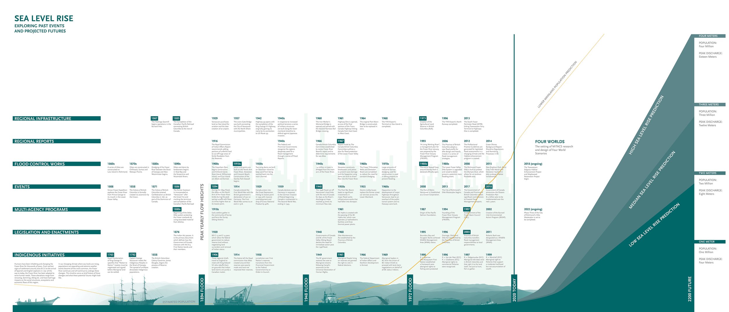
In order to better understand the interrelationships between key flood events, flood management measures, settlement patterns, infrastructure developments, and legislation developments, the FRDC first developed a timeline of shoreline transformations, designed to be printed and exhibited at a large scale. Data and information for the timeline was garnered from hundreds of planning reports, policy documents, archival resources and municipal websites. On this timeline, the x-axis (horizontal) organizes information according to time, from pre colonial to present-day, projecting into the future. The line at the bottom documents major flood events, key legislative decisions, publication of important planning studies, as well as the formation of public entities that deal specifically with the issue of flood management. The other horizontal lines map the history of flood control measures that have been implemented in the region, each line representing a different solution: 1) dredging, 2) dams, 3) dikes, 4) groins/jetties/breakwaters, 5) seawalls, as well as 6) the reuse of dredge spoils, and 7) habitat restoration/nature-based solutions. The y-axis (vertical) maps the peak discharge volumes of the Fraser River, with major flood events highlighted in magenta. The yellow line represents the population growth of Metro Vancouver.
The timeline reveals the extent to which the delta and its shorelines have been transformed and manipulated over time. It also shows that, with the exception of some dike upgrades, the majority of flood control measures in the region were completed by 1970. This not only underlines the fact that current flood protection is reaching the end of its lifespan, but also that few of these infrastructures would likely meet current design standards. Moreover, there is a strong correlation between flood events and subsequent adoption of legislation and/or the establishment of special projects. One such example is the Fraser River Model Project Office (1948-1963), which was established in direct response to the flood of 1948, and enabled the construction of a large scale hydraulic, erodible-bed, tidal river model to test and improve flood management and navigation in the Fraser River Delta.

Interconnected Issues
Developing potential adaptation pathways to climate change must be done in ways that acknowledge these complex interdependencies between social and ecological systems. This begins by understanding the spatial variability in projected SLR and resulting shoreline change from a decade-to-century scale.
We have examined five areas of concern with respect to flood adaptation in the Fraser River Delta:


